
- The Indus Plain
The word Indus is derived from Sanskrit word ‘Sindhu’ which means ocean. The words Sindh, India and Hindu also come from the same word. River Indus is one of the world’s great rivers. Almost all of the major rivers of Pakistan flows into Indus.
River Indus Basin is a large and very fertile plain formed from the River Indus silt. This area has a 5,000 years old civilization with agriculture as the main source of income. The main parts of the Indus Plain includes Upper Indus and Lower Indus Plain.
The upper side of the Indus basin includes the Province of Punjab and the Lower Basin starts at the confluence of the eastern tributaries extending south wards to the coast. The high area of the Indus Plain is known as the Potohar Plateau located close to the foot hills of Himalaya Mountains. There are four deserts in the Indus Plain namely Thal, Thar, Indus Valley and Cholistan.
- Upper Indus Plain:
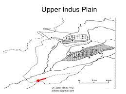
There is a vast plain located on the east of Kirthar and Sulaiman mountain ranges and south of Salt range extending up to the Arabian Sea. River Indus and its tributaries irrigates this area including River Sutlej, Ravi, Jehlum and Chenab.
These tributaries meet the great Indus at Mithan Kot and on its south lies the Lower Indus Plain and on the north is the Upper Indus plain. The upper portion of River Indus is very fertile despite the fact that there is few rainfalls in this area, mainly because it comprises of the soil broth by the rivers.
Long chain of canals are spread in this area which help produce a good quantity of crops. This canal system is one of a kind in the world. There are few hills of low heights seen around Chiniot, Sangla and Sarghoda.
Thal desert lies on the west of River Jehlum which used to be an arid area. But due to intense irrigation by the canals coming from the Jinnah Barrage this desert produce lots of crops. There are many Doabas including Ban Doab, Sagar Doab, Singh Doab in the District Sahiwal and Multan.
A large part of this huge desert is populated only because of this irrigation system which in turn helps produce different types of crops. The plain becomes higher and higher and this raised part is known as Daras.
The plains of Peshawar and Bannu are also very fertile which lies in the north of Daras. This is also due to canal system of irrigation and tube wells. Many crops are grown in this region including; rice, wheat, cotton, sugar cane, oil seeds and tobacco
b. Lower Indus Plain:
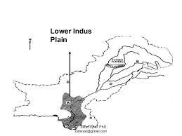
The area in the south of Mithan Kot to the Arabian Sea is known as The Lower Indus Plain, which comprises of most of the area of Province of Sindh. The soil is very fertile and where every proper supply of water is available crops can be grown.
Several canals have been made in the north of the province and the central part of Sindh is irrigated by a large network of canals. The Thar Desert is however quite infertile due to lack of water and is located in the east of this plain.
Near Thatha the Indus becomes closer to Arabian Sea where almost 556,000 acres of swampy delta is formed including mangrove forests. This delta then divides into several branches and falls into the Arabian Sea afterwards.
During the monsoon a large part of this area is flooded with water creating destruction. The seaport of Karachi is located on the west of this delta and salt marshes of Rann of Kutch lies on its east.
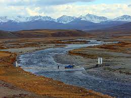
- 2. Deosai Plain:
The meaning of the word Deosai is ‘Land of Giants’. This plain is located on the boundary of Karakoram and western Himalayas and comprises of an area approximately 3,000 sq. km. It is about 30 km from Skardu. This is the world’s highest plateau.
It is snowcapped most time of the year with no trees or even shrubs. The plain is accessible from Skardu and the Astore valley in a brief summer season only. But it turns into a paradise like place in summers with millions of flowers, lots of greenery and a background of snowcapped mountain peaks.
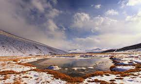
Sheosar Lake in this area also provide beautiful views. It is filled with purple meadow cranesbill, mauve Eritrichium and Aster and yellow Pedicularis and Poppies and many more in the month of June. It seems like a sheet of colorful flowers on the slopes.
This place has a unique biodiversity. It is interlaced with lots of streams and golden marmots. Trekkers come to this area from within and outside Pakistan and enjoy the mountains till September. There is a track crossing Deosai plain to Skardu and Astore Valley.
This track goes to the Satpara Lake from Skardu and a small village. Deosai is surrounded by snowcapped mighty mountains exceeding 5,000 m height. Spring comes a little late in this area, but once it is here, it comes in full bloom.
The vast alpine flowers grown in this plain are one of a kind. In the spring season, thousands of wild flowers fill up the green grass land with Fiona flora getting most part of the attraction. Thousands of tourists rush to visit Deosai in summers with spectacular views of the great Karakoram Mountains from the height of about 4,785 m.
Many wild animals live in this area including the Brown Bear. Deosai at an elevation of 3,500 meters is officially a protected area for wild life and the Deosai National Park is also another tourist’s attraction spot. It is located at approximately 13,500 feet above sea level and is above the tree line. It has an area of about 3,000 sq. km and is tourist’s paradise.
Camping is quite common in the area in the summer season which is mostly done on the bed of edelweiss and river or lake side. Chakor Pass is another attractive stop of the area which is 4,266 m high and is situated in the south of the plateau.
Lake Shausar also give another spot worth seeing to the visitors. The great Karakoram Mountains on the north of this pass provide a very beautiful view. This area with an endless and unspoiled natural beauty attracts thousands of tourists.
With the beauty of soaring mountains, shiny glaciers, crystal clear lake water, natural streams, alluring river sides, alpine pastures and many neighboring attractions the trip to Deosai becomes an unforgettable experience. People who love adventure and trekking will find this a heavenly place.
- Coastal Area.
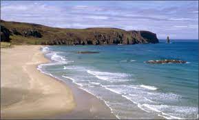
The total coastal area of Pakistan is about 1100 km long and is located in the Province of Sindh and Balochistan. The longest one is in Balochistan which is 770 km long. The coastal area starts from the border between Sindh, Pakistan and India and ends at the border between Iran and Pakistan.
It is present on the shore of the Arabian Sea. Geographically, it has great importance as it connects Pakistan with the neighboring countries. There is a strong possibility of presence of mineral oil in the sea that is why the government is paying a lot of attention in its progress.
In the Sindh coastal area, Karachi is the most important part because of its sea port. Karachi Port is located between the towns of Kimari and Saddar and are close to various industrial areas and the business district. Karachi is a metropolitan city with the busiest seaport.
It handles around 60% of Pakistan’s cargo which is 25 million tons every year. In the coastal areas of Balochistan, Gawadar has the most important place. It is a deep sea port with warm water at the entrance of the Persian Gulf and around 460 km from Karachi city, south of Makran and about 47 miles away from the eastern border between Pakistan and Iran.
It has developed as a district along the sea in this region. The coast line here is around 600 km long. Its port has a potential of becoming the hub of trading activities between Pakistan and Central Asia.